INTERVIEW
Camila Calhoun
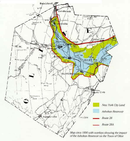
The Community That Watershed Development Forgot: Eminent Domain and A Town Called Olive
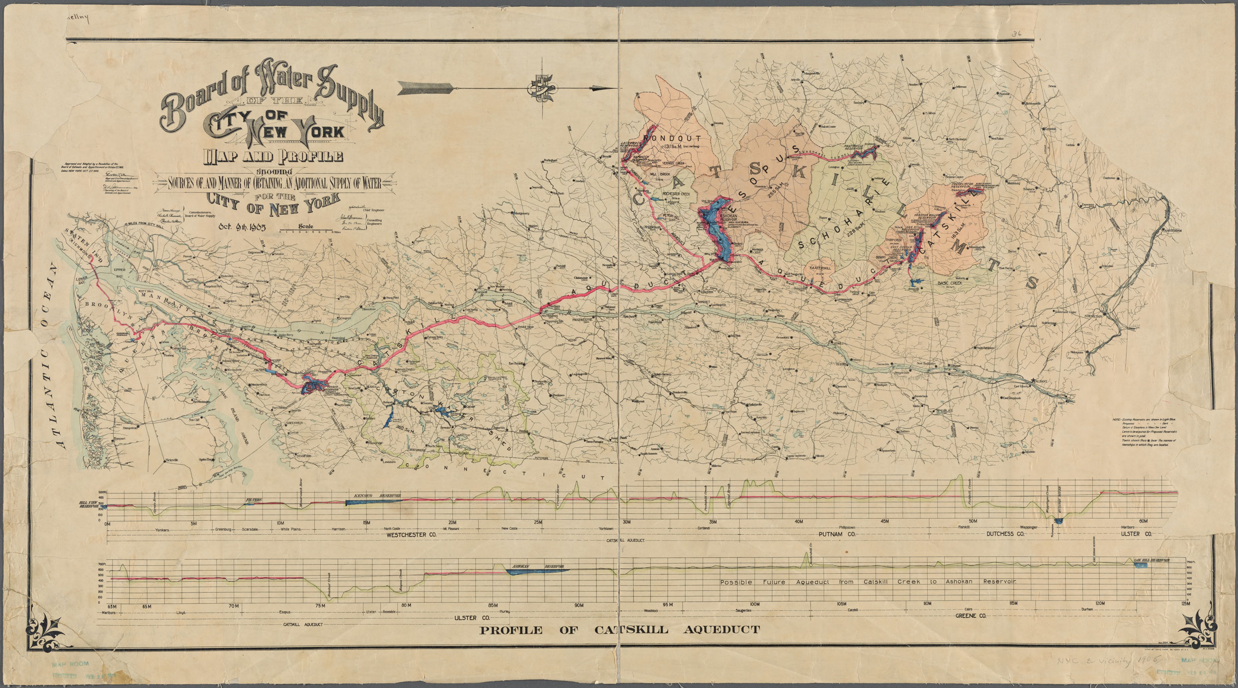
With the consolidation of Greater New York in 1898, there were suddenly many more people relying on the City’s public water supply. In 1905, the New York State Legislature established the Board of Water Supply (BWS) and imbued the Board with significant power to dictate land use, seize land through eminent domain, and realize a massive expansion of the New York City water supply.
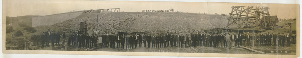
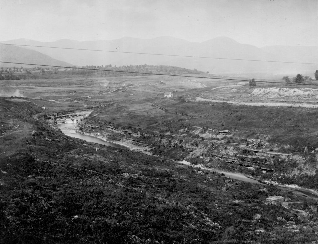
Attempts to expand the existing Croton System northward to Dutchess County failed when residents mobilized in opposition to this plan. But by August 1905, the BWS ordered engineers to draw up maps and develop a plan to transport water from the Catskill Mountains west of the Hudson River south to the City. Soon they identified Esopus Creek as a potential site for the development of a massive reservoir and retaining dam, which became the centerpiece of the Catskill branch of the NYC water supply — the Ashokan Reservoir. The City submitted its plans to the State Water Supply Commission, which began a series of public hearings in the Catskill region. Many locals voiced opposition to the City’s plans to seize their land and transform the landscape and their livelihoods with it.
Despite legal challenges, City Hall’s influence held. When the dust settled, 8 villages ceased to exist, 2,000+ residents had been forced to relocate, and 500+ homes and 10 schools were destroyed. For those who lost land, this project of urban expansion was devastating, upending a way of life that could not be recovered.
Camila Calhoun wrote “A Town Called Olive: A Perspective on New York City’s Water Supply” in 1997. The essay chronicles the story of the forgotten town of Olive in the Catskills, where her ancestors were uprooted for the sake of expanding NYC’s drinking water. Chloe Kellner spoke with Calhoun in July 2020 about watershed consciousness and the impact of the Ashokan Reservoir on different generations.
Chloe Kellner: A recent interview mentioned you were expanding your essay, “A Town Called Olive,” into a book. What parts of the essay are you expanding or focusing on, for the book?
Camila Calhoun: The book is going to be focused on Asa Bishop, my great-great-grandfather who came to the town of Olive in 1790 and built the grist mill which became a local legend up there. It’s hopefully going to be a historical fiction piece.
CK: You have a background in art and have a gallery now, what brought you to focus on contemporary art? And can you share your journey through different forms of communication?
CC: My professional life is a lot of going from one career to the next. I studied art history and fine art in college and then when I left college, I worked at the Frick Collection for a few years, and that was amazing. I also worked at another gallery that is on the same street as the Frick. I had gallery and museum experience, and I started writing while I was working there. I went abroad to Italy in my junior year, so I really wanted to go back to Italy and write. That completely shifted my life. I left the museums and lived in a friend’s villa and ended up staying there for four years, and got married there. Fast forward to now. I’ve just published a book called The White Moth which is about my Italian mother-in-law and three generations living in this villa in Tuscany. So I had been writing, and then after we had two kids and they got older I started getting really concerned with environmental issues. I went to NYU for a master’s in environmental conservation and education.
I don’t know, maybe I was fueled by this quest for water. I guess I’m drawn to water. I started a project called the Watershed Education Project, which was with the Saw Mill River. All the students along that river would get together and do interdisciplinary projects. It’s the river that spits out into the Hudson River in Yonkers, so there was an upstream/downstream study and a symposium on land use. Watershed consciousness is something I always connected to, and this knowledge of what happened upstate is one of the things that was the impetus for that. When the land trust that I was working for wanted to shift to just preserving land and not teaching children, I left and started a gallery in Beacon, NY with a friend. We were there for a couple years before deciding there wasn’t enough traffic. So we decided to take our show on the road. It’s called Kiesendahl and Calhoun Fine Art and it’s been great. It’s a part-time art business that’s allowed me to also be able to write.
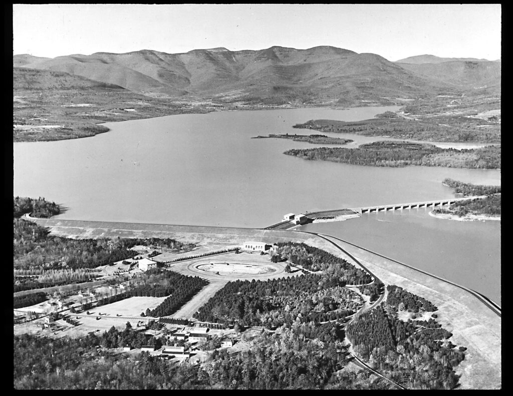
“The great expanse of Ashokan water appears, when full, like a natural crater lake nestled in the Catskill Valley. A dividing weir and a 15-arch bridge separate the east and west basin. It seems unreal to think the town of Olive was once under those waters. But Olive was only one village destroyed to form the west basin of the reservoir. West Shokan, Brodhead Bridge, Brown Station and Boiceville were also once located there. The east basin displaced the villages of West Hurley, Glenford and Ashton. In 1913, when my mother was 4 months old, born a few miles away from the reservoir, the city began filling the west basin.”
—From “A Town Called Olive”
CK: Would you mind sharing your connection to the Esopus Valley and Catskill region?
CC: My mother grew up on a farm there; her mother’s name was Bessie Bishop and Bessie’s husband was Lester Lewis. It was a dairy farm. I was just there this weekend because the homestead and house is still there in Olivebridge. My mother was born in 1913 when the west basin was filling, so they were directly impacted by that whole project. But more [impacted] than anyone in the family, was my grandmother Bessie’s family and home. They had a general store and their home was among the first to be condemned. They were among the eight different families that had to leave the valley. It was a fertile valley thriving with churches and railroads. They definitely condemned a whole huge area and you know, the city didn’t really compensate. So there was a lot of bitterness about the “city people” and about being unfairly compensated. My mother married someone on Long Island so I only went up to the country in the summers and on occasion during the rest of the year. But I do still have relatives there.
CK: In “A Town Called Olive,” you mention your grandmother asking her father, “How can they be allowed to take our home?” Obviously being displaced from your home can have a deep emotional toll (as well as financial). Are there any stories you could share about other families or your own that had to move?
CC: I wasn’t alive when they were in the process of moving, but I do remember the town historian, Vera Sickler. She would tell me stories about being young and going to the Boyceville reunion every Labor Day, where the people whose land had been taken would get together and kind of commiserate. People’s lives were upended. Most people moved to the hills, the surrounding towns, or just dispersed. My grandparents basically died not too long after they had to move. I can’t imagine that the whole being uprooted didn’t have something to do with their dying. Because of my research I knew of the different people who got the short end of the deal. There was one woman who was a ginseng farmer. I imagine that was a really hard thing. How do you replace a ginseng farm? The city gave her a certain amount but she had to start all over again. They were very unequal in the way they gave people the value for their homes. I don’t know how they came up with the numbers. I remember my grandma saying how hard it was because all of a sudden the valley was filled with all these construction workers. Then the Department of Environmental Protection (DEP) was basically started as a way to keep the peace there while they were doing the construction because there was a lot of commotion and rowdiness. Today, people go over the dam and they see this beautiful place. It’s hard to imagine that underneath there a quarter away from the west basin is where Bishop Falls was. Mayor Koch actually brought attention to this because whenever there was a drought you could see the foundations of the houses there. And one woman went in and found a doll. You can still see the traces of it when the water is really low, but when it’s full it’s a magnificent body of water nestled in the mountains.
CK: When you interviewed Vera Sickler in 1992 (the town historian and one of the few remaining survivors of that era), you mentioned that she wasn’t bitter and that the Ashokan Reservoir was bringing tourists. What are some tradeoffs (positives or negatives) that you’ve witnessed or learned about for people who currently live within the watershed?
CC: It’s one of the attractions because you can ride bikes or walk over the dam. There’s been a lot of people from the city who have a second home there or retire there so the local economy has been helped out by the influx of people. I guess the tradeoff has been that local businesses and restaurants have benefited from that.
CK: What do you believe is the best way to protect water quality while also considering the livelihoods (and potential animosity towards the city) of people living there now?
CC: There was a lot of concern about the development. I think the watershed is now well protected. When I was writing, there was still some concern that they wouldn’t pass enough legislation to protect the land and they would have to have this huge filtration system [Editor’s note: see our interview with Diane Galusha regarding the 1997 agreement that allowed the city to avoid water filtration]. The water has been such good quality for NYC. I think they’ve done a really good job with the regulations and then the people who live there pay lower taxes because the land is owned by the city. But then there’s that tradeoff because people can’t really develop their land or sell the property.
CK: Because of its high population, NYC ends up needing resources from the land base of NY State for countless things besides water. Having lived in both NYC and Tarrytown, what’s your perspective on how NY State residents may feel about often being the site of extraction for NYC? And what can NYC residents do to alleviate pressures or stand in solidarity with NY State residents?
CC: I think that most of the people that used to go to the Boyceville reunion are gone. I think with generations it starts to soften that bitterness. At this point, it’s been over 100 years since the towns were flooded. And people did eventually get used to it. Maybe there’s animosity toward city people for other reasons, but not so much the water.
CAMILLA CALHOUN is a writer who lives with a view of the Hudson River in Tarrytown, New York. She has written a collection of essays dealing with the loss of her beloved husband Aldo in 2016. Always interested in the connection to and loss of place, she is currently working on a historical novel based on her published essay, “A Town Called Olive.”
CHLOE KELLNER is a junior at Vassar College from New York City. She is majoring in environmental studies and geography, with concentrations in urban studies and biology. Chloe is interested in urban design and planning, as well as improving food systems. In her free time, she plays piano and harp and enjoys spending time with family and friends.