The Pleistocene

Fast forward to 2.6 million years ago and in the Pleistocene Epoch glaciers carried along vast amounts of sands, soils, gravel, and boulders leaving deposits up to 300 meters thick in some valleys. This left the Catskill region low and flat, and hollowed existing trenches as mammoth ice sheets repeatedly advanced across New York State. The towering ice widened and expanded former river valleys to make the Finger Lake troughs. Some of the finger lakes were pushed down so deeply by these glaciers that their earlier bedrock floors lie below sea level.

A satellite photo of the Finger Lakes region of NY with regions covered in snow
The Finger Lakes region of central New York after a snowstorm, as seen from the International Space Station. The steep, roughly parallel valleys and hills of the Finger Lakes region were shaped by advancing and retreating ice sheets that were as much as 2 miles deep during the last ice age (2 million years to about 10,000 years ago). River valleys were scoured into deep troughs; many are now filled with lakes. The two largest lakes, Seneca and Cayuga, are so deep that the base of their lakebeds are below sea level. Image: NASA / Public domain.

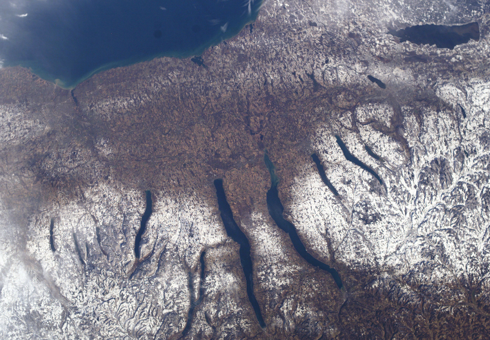
“All the streams in the Bronx run from north to south, reflecting grooves in the land left by the retreating glaciers of the last ice age. Individual ponds and lakes are the products of ice blocks that detached from the glaciers.”

Sergey Kadinsky in Hidden Waters of New York City, p. 62.

A satellite-generated image of New York state looking North West. From Lake Ontario and the St. Lawrence River (at the top of the image) and extending to Long Island (at the bottom). On the left side are the Catskill Mountains, a part of the Appalachian Mountain chain, where river erosion has produced an intricate pattern of valleys. To the northwest (upper left) of the Catskills are several long, narrow lakes, some of the Finger Lakes of central New York. The Hudson River runs along a straight valley from right center (near Glens Falls), widening out as it approaches New York City at the lower left on the image. The Ashokan Reservoir can be seen in front of the Catskill Mountains, just left of the center of the image. Image: NASA Jet Propulsion Lab, 2000.

“In terms of its geomorphology—that is, the shape of the Earth’s surface—the land beneath the Ashokan Reservoir suggests itself as a proper place for a lake of sorts. Although not volcanic in nature, the Ashokan Reservoir occupies a spot prepared for it by glaciers that arrived from further north a few million years ago. Glaciers ground and gouged the land. They pushed up piles of rock debris. One pile of rock debris—called a moraine—plugged a bowl-shaped space carved by a glacier, and a vast glacial lake accumulated behind it. Really Ashokan is a perfect place to put a reservoir because, as geology tells us, one was there once before.

Jill Schneiderman in The Earth Around Us: Maintaining A Livable Planet, p 174. 

Left arrow (previous post)
Up arrow (back)
Right arrow (next post)